
Kemarin tanggal 2 Juni 2017 di kelas IELTS Modular English Studio, saya dan para peserta membahas Writing Task 1 Map. Agar kamu dapat menyelesaikan penulisan Map ini dengan cepat dan akurat, lakukan 2 langkah ini:
1. Kamu cukup memfokuskan pada perubahan yang nampak pada Map.
2. Gunakan deskripsi paragraf dan kelompokkan objek-objek tadi berdasarkan tahun yang ada.
Berikut contoh esai writing task 1 yang kami selesaikan di kelas Modular kemarin.
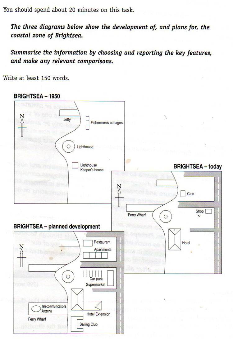
The development of a coastal area of Brightsea chronologically from the past condition to the recent one and the blueprint of its future design is presented in the diagram. Those maps are compared based on the changes madeKamu juga dapat membaca contoh tulisan saya dengan topik yang sama. Skor esai ini band 7.5 versi testbig :
With regard to business centre, café and shop has replaced fishermen’s cottages in the north east of the map. In the planned development, these two business assets are predicted to be demolished, and therefore restaurant will be built while supermarket will be established in the east of Lighthouse. Again, the north-east development is forecast to construct some apartments and another development is the hotel in southeast of the coastal zone which will be extended to the east.
Turning into the public service, people visiting this place can park their car next to supermarket as the planned development. There will be a sailing club around the area of the hotel, and the south west area, people will see a Ferry Wharf with Telecommunication Antenna, while there are no changes in the main road in the east of the map.
The ongoing development of a coastal belt of Brightsea from the 1950s onwards appears in the map.Ok guys, pembahasan sesi Writing IELTS Task 1 Map cukup sampai di sini. Sampai jumpa lagi pada postingan tips dan trik IELTS lainnya.
Before the commercial purpose could take place in 1950 onwards, the Brightsea’s local government started to build a house for lighthouse keepers and a lighthouse, which was under constant close surveillance day and night. Also, there were few cottages of fishmongers down to the small detail with a jetty.
A more detailed look at the map shows that in today’s development the cottages and the house of lighthouse keepers have been demolished. This may be because the central activity in the Brightsea area takes place in the commercial purpose, where can be clearly seen from the map that a hotel, café and shop are built into the zone, while a ferry terminal and a main road for commuters have also presented recently. Surprisingly, several years further on, there will be telecommunication antennae in the peripheral zone of the ferry terminal. Again, the shop is reversed into a large supermarket with valet parking for visitors. In the northern part of this coastal belt, the development will consist of a family residence and restaurant, which was used as a cafeteria.
What can be drawn from the map of the coastal belt of Brightsea? Fast forward now to the 1950s the development has dramatically changed. While the lighthouse is the constant landmark, there seems likely that the ferry wharf will have a more significant change.
Jika butuh guru private IELTS, silahkan kontak di nomor 0813-1033-6583 atau 0813-1818-6060
